In the second post of a three-part series about the evolution of Indoor Positioning Systems (IPS) and wayfinding, we discuss the importance of indoor wayfinding and how innovative organizations use this technology to enhance people’s experience with spaces. Missed the first part, Crossing the Chasm for IPS? Find it here to get caught up.
“You can’t use an old map to explore a new world.”
Albert Einstein
For most of human existence, there have been maps. From prehistoric paintings to the turn-by-turn directions spoken by our smart devices in real-time, we’ve seen fantastic innovation in the tools that allow us to discover, explore, understand, and navigate our environment. The methods and solutions have evolved, but the core building blocks remain the same.
The value of mapping spaces
Maps are not simply a tool to help us get from Point A to Point B – they provide the context we need to understand a place or information related to spaces and solve problems in new and familiar areas. Traffic predictions using Internet of Things and global positioning systems (GPS) data displayed on digital maps help us choose the best route and modes of transportation. Point-of-interest data helps us discover our destinations and gives us peace of mind businesses will be open when we arrive. Not only do they provide a list of possible routes, but these technologies help us while we’re on the way. If changing conditions along the route affect our ability to reach the destination, modern maps respond in real-time to help us discover alternate routes, reduce risks, and mitigate delays.
While the ability to navigate the outdoor world has become a quintessential part of our daily lives, navigating within indoor spaces (wayfinding) is an evolving technology. Advancements in indoor positioning systems (IPS), sensors, mapping technologies, and mass adoption of smartphones bring the digital precision we’ve come to expect from outdoor maps inside the buildings where we spend most of our lives. Today’s technology allows us to realize new value from maps and indoor wayfinding as part of an immersive experience within spaces – not just a tool to get us there.
Whether a journey is five steps or 500 miles, the highest value a map provides is context. Proper context confirms that we haven’t strayed off course, allows us to become quickly oriented, or helps us discover what exists in an unfamiliar space. Maps use visual elements like point of interest (POI) markers to highlight landmarks or other important areas. Easily accessible, relevant information attached to those POIs provide additional context to help us make decisions about a trip.
The difference between outdoor and indoor wayfinding
How do we determine what information is relevant and valuable for a person using a map? It starts by understanding the goals, desires, or problems they’re trying to solve.
Outdoor wayfinding applications help us navigate great distances with relative ease. But GPS map makers know very little about the people using them – besides the location where they started and the desired destination. It’s not clear why a person needs to go to a particular place or what they want to do in that location.
Indoor wayfinding applications are inherently different because buildings are confined within established boundaries – walls and ceilings – and are created to serve specific purposes for people using those spaces. For example, shopping malls are built for commerce, airports are designed as air travel hubs, factories are places to make things, and warehouses are for storing those things. People who map indoor spaces typically know why someone is in a particular location.
So, while we know a mall visitor is likely shopping – could additional context improve that experience? Someone in a warehouse is probably working – can we deliver more context to help them complete tasks quickly and easily? The private and confined nature of indoor spaces offers granular control over IPS map displays. Business operators can contextualize points of interest according to how various areas impact guests and associates. They can include or omit operating hours or a location change. The map’s visuals and contextual data shape how people experience a space.
Indoor map makers also contend with several disadvantages. For example, outdoor maps can be automatically produced with aerial footage; it’s difficult obtaining high-quality and consistent data of building interiors. Similarly, exterior maps are created from abstract and arbitrary geometric shapes; mapping building interiors requires knowledge of how precise geometric shapes fit together.
That’s the critical difference between outdoor and indoor wayfinding – indoor maps unlock new opportunities to design and influence people’s experiences within spaces. The simplest forms of indoor wayfinding make navigating and exploring new or unfamiliar spaces easier. The most robust and interactive indoor maps build brand loyalty, empower associates, and impact customers’ experiences.
Designing Unique Experiences Through Indoor Wayfinding
Wayfinding, at its core, is about enabling people to solve problems and achieve their goals. But problems and goals are subjective – unique to each person and setting. And they change in response to new information.
Most people may use indoor maps to:
- Search for particular items
- Navigate to a specific location with step-by-step directions
- Receive real-time updates on any changes to their existing route
For building operators to support employees and create valuable guest experiences, they need to know who’s using the indoor maps and for what purpose. For example, if a sales associate at a hardware store wants a specific replacement part, they need to know the exact aisle and shelf location. However, someone browsing for a down coat might only need general directions to the winter clothes.
Indoor wayfinding technology allows us to provide relevant context to people exactly when and where they need it to help them achieve a specific outcome. For example, why are they inside the space? What do they need from the location? What information is most valuable to them?
How context influences personal experiences within the built environment
IPS provides both the user and operator with additional context information. While the bulk of wayfinding is centered on a good map and the ability to search the space and navigate to a destination, IPS provides additional supporting information. Specifically, IPS helps users orient themselves by showing them where they are on the map. Likewise, operators get data-driven insights into how effectively guests accomplish their objectives in the mapped space. Here are a few scenarios where indoor wayfinding features might significantly impact an employee or guest’s experiences:
- A retail associate in a big box store
- A new employee on a large corporate campus
- A passenger visiting an airport for the first time
Consider Sonny, a retail associate in a big box store
Like many retail associates, Sonny has a wide range of responsibilities. His company recently integrated wayfinding features into their store app to help employees do their jobs more efficiently and better serve customers. Now Sonny can find equipment (e.g., forklifts, ladders), quickly fill curbside orders, and answer customers’ questions about item availability. And as helpful as this is, additional context beyond location and directions would be useful.
If Sonny needs a barcode scanner and his interactive store map shows three available within a two-minute walk, he’ll likely choose the closest location. However, if he arrives to find that scanner’s battery isn’t charged, he’s wasted his and possibly a customer’s time. That’s a negative brand experience for him and perhaps a shopper. Fortunately for Sonny, the app’s indoor map displays scanner battery life, and he can complete his task on the first attempt. In this case, Sonny needed more context than a location to efficiently complete his assignment or help a customer. By trying to understand and include role-specific information, Sonny’s employer enabled a positive indoor wayfinding experience for an associate and possibly a customer.

Consider Starr, a new employee on an expansive, newly constructed, high-tech corporate campus
Starr’s new company thoughtfully added indoor wayfinding features to their internal mobile app to help employees navigate and discover events and amenities available on the new campus site.
During her first day, Starr shuffles between a full slate of new-hire onboarding presentations, meetings with supervisors, ice-breaking activities with coworkers, and a trip to HR for her new employee photo ID. Since she’s still unfamiliar with the campus and each building, Starr relies on the company’s wayfinding software to get between buildings and locate the correct office or meeting space inside each. She conveniently schedules her photo appointment inside the app, saving an extra trip to HR and giving her enough time to get to her welcome luncheon in a different building. Thankfully Starr’s mentor, who’s already at the event, shared her location. Starr brings up the step-by-step directions and heads off feeling confident and welcomed.
By combining context and functionality in a user-friendly app, Starr’s company significantly enhanced Starr’s new employee experience.
Consider Keith, a passenger visiting an airport for the first time
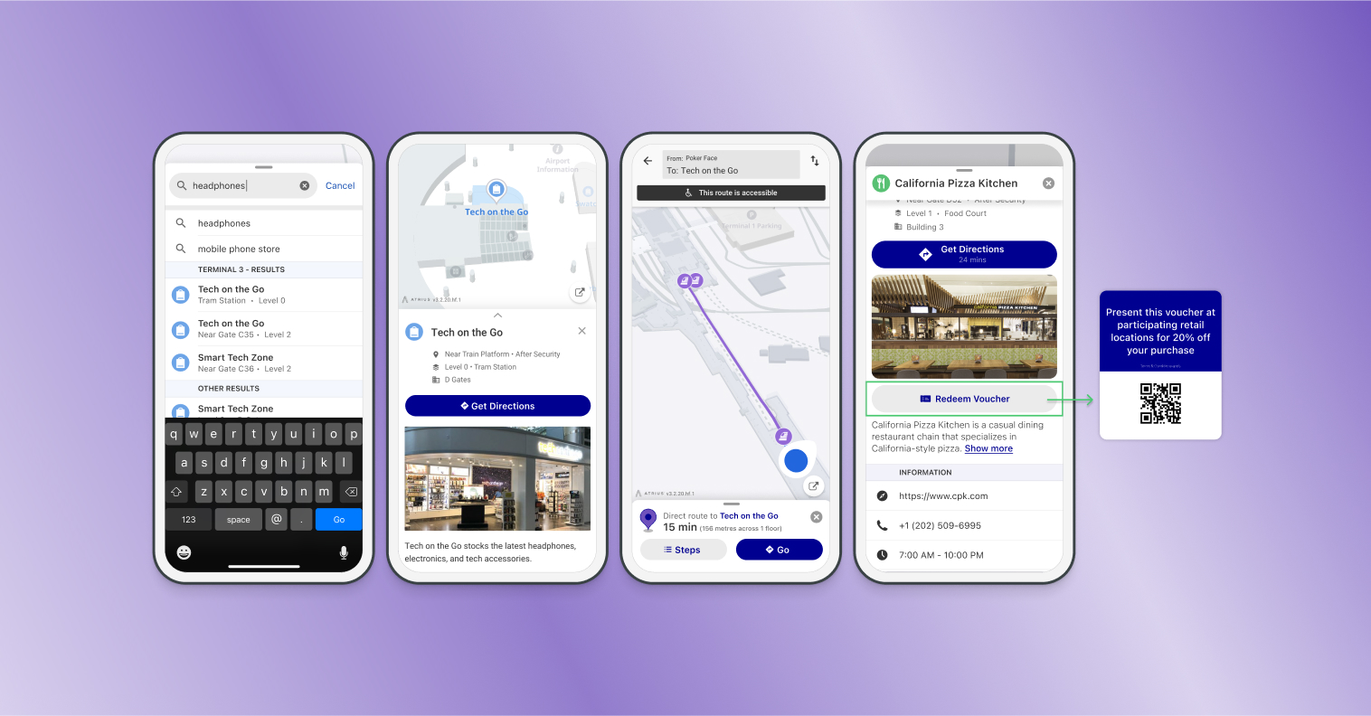
The airline Keith’s flying recently updated its app to include indoor wayfinding features like interactive terminal maps, live security wait times, and the ability to order food for pickup. When Keith checks into the flight he can explore the airport and amenities on the way to his gate. While points of interest and step-by-step directions help Keith easily navigate where he needs to go, the additional context within the map can shape his entire experience at the airport.
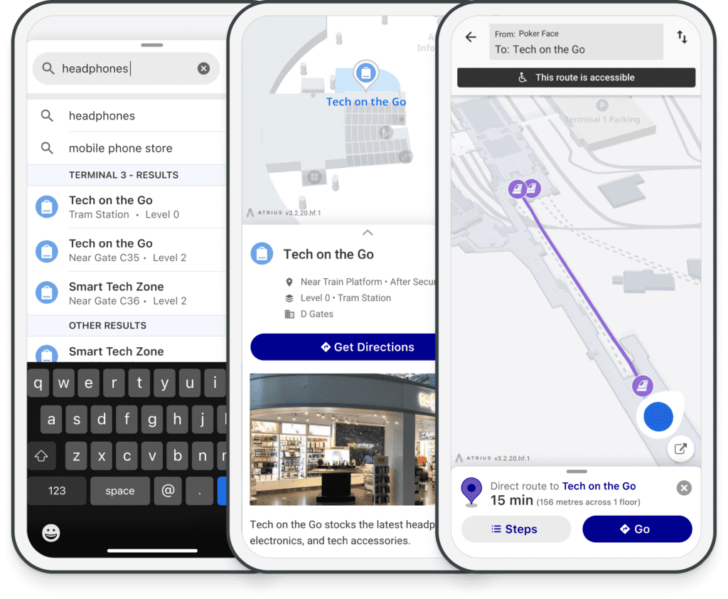
Keith is feeling pressed for time because of the traffic on the way to the airport, and he’s worried he’ll miss his boarding time trying to get some food before his cross-country flight. He opens the airline’s app and discovers a few fast-food options nearby, but his favorite pizza spot is on the other side of the terminal. With live walk times, flight information, and the ability to order food in the app, Keith’s confident he can get there, wait for his order, and still be at his departure gate on time. When a prompt from the airport map offers a coupon he can redeem at the nearby retailer, he has time to grab a slice of his favorite pizza and also pick up new headphones for the flight.
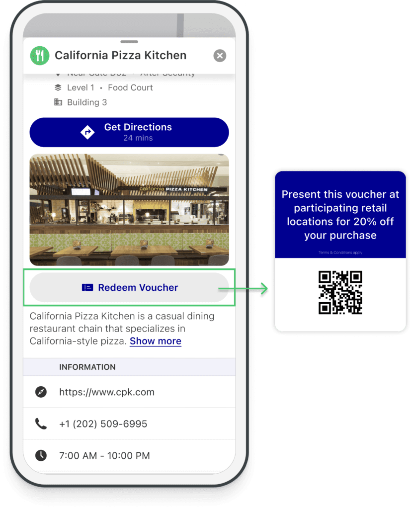
Not only did the map deliver the right context to Keith when he needed it most, but the contextual information changed his entire airport experience. He started the day rushed, stressed, and unsure if he’d be able to get food and make his flight. Indoor wayfinding features resolved the uncertainty and his hunger!
Why indoor wayfinding is important
As buildings evolve and become more complex, indoor wayfinding technology will continue to play an essential role in how employees, occupants, and visitors experience these spaces. In each situation above, operators leveraged user knowledge to visualize and contextualize indoor areas for the people interacting with those spaces.
At its basic level, IPS helps people discover and access indoor points of interest. Advanced indoor wayfinding solutions empower owners, operators, and managers to intentionally and seamlessly influence how people experience these spaces. With indoor maps already impacting our lives, it’s intriguing wondering what’s next. If you’re an Atrius customer, “next” is “now.”
The end is here! Look out for the final chapter in our series about IPS where we discuss our newest Atrius product designed to enable digital precision over every physical space.
