Product Launch: Atrius® Personal Wayfinder on Digital Display revolutionizes how airport leaders craft helpful, personal passenger experiences and deliver contactless, safe travel.
Demand for contactless experiences drives innovation
The past year had an undeniable impact on travel, but one thing hasn’t changed – the need to make airports more discoverable and easier to navigate.
As the pandemic engulfed the world in early 2020, airport leaders focused on maintaining passenger safety and according to Kevin Burke, President and CEO of Airports Council International-North America, “Many of these changes will outlast Covid-19.” Addressing this extraordinary situation brought operational adjustments, too. Many teams took their touchscreen displays offline for safety reasons were left searching for ways to re-engage these investments.
That’s why we’re excited to announce our product, Personal Wayfinder on Digital Display, a solution that gives passengers access to the critical information they need with a touchless, mobile-friendly option.
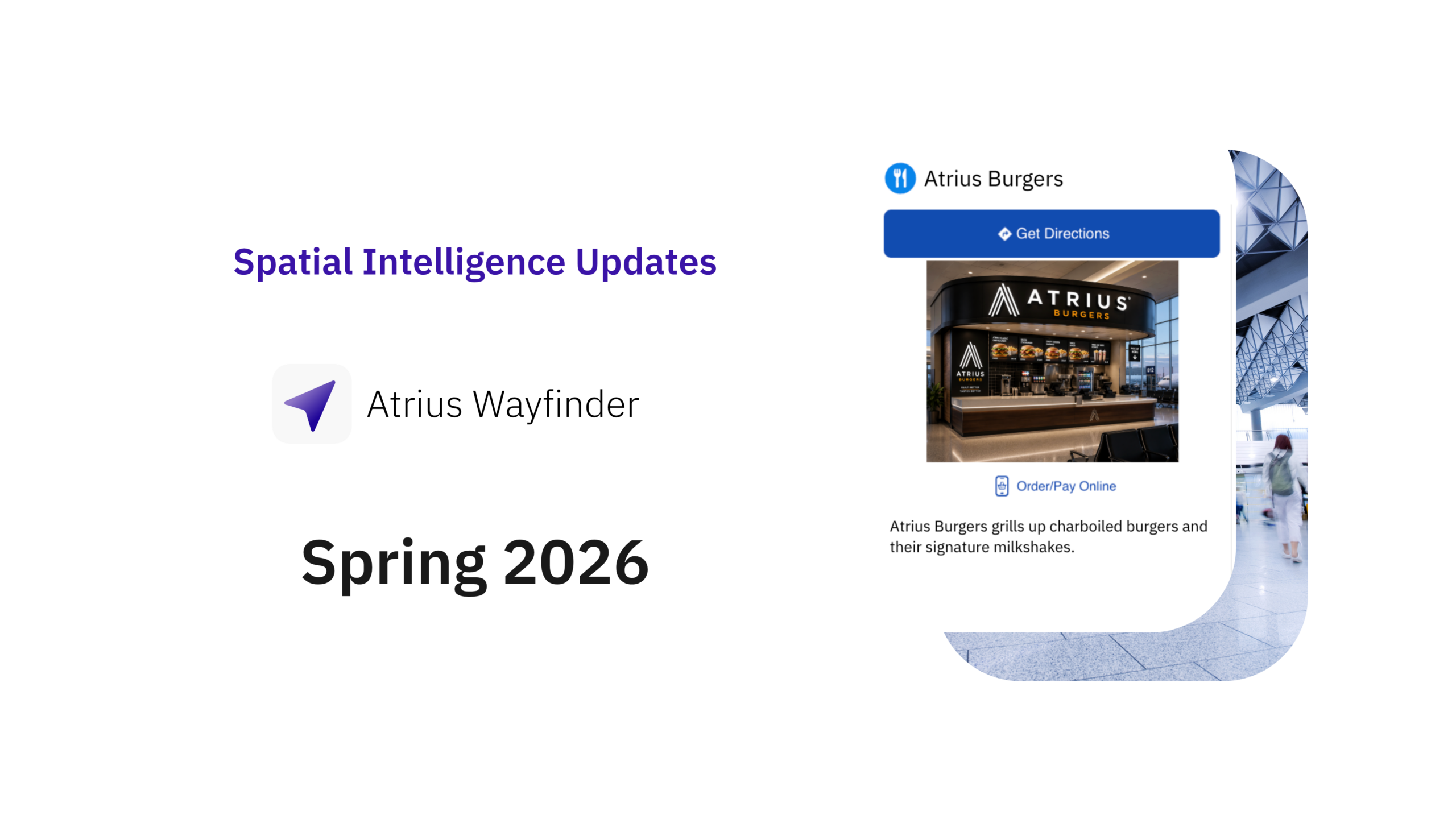
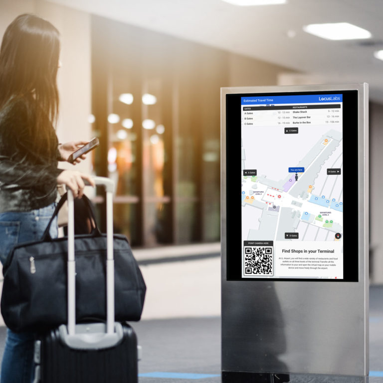
With our technology, airports can transform static display directories into dynamic, contextually relevant, interactive digital experiences. It allows communication teams to highlight constantly changing information, including concession locations, operating hours, Personal Protective Equipment (PPE) stations, and available amenities.
To create a completely contactless exchange, airports can embed QR codes directly onto the displays. Passengers scan these QR codes to start user-friendly contextual searches and wayfinding experiences on their own mobile devices.
To showcase Personal Wayfinder on Digital Display, product manager Jessica Irvin outlined three scenarios that show how our technology reshapes how people operate, work in, and travel through airports.
Activate every screen with touchless interactions
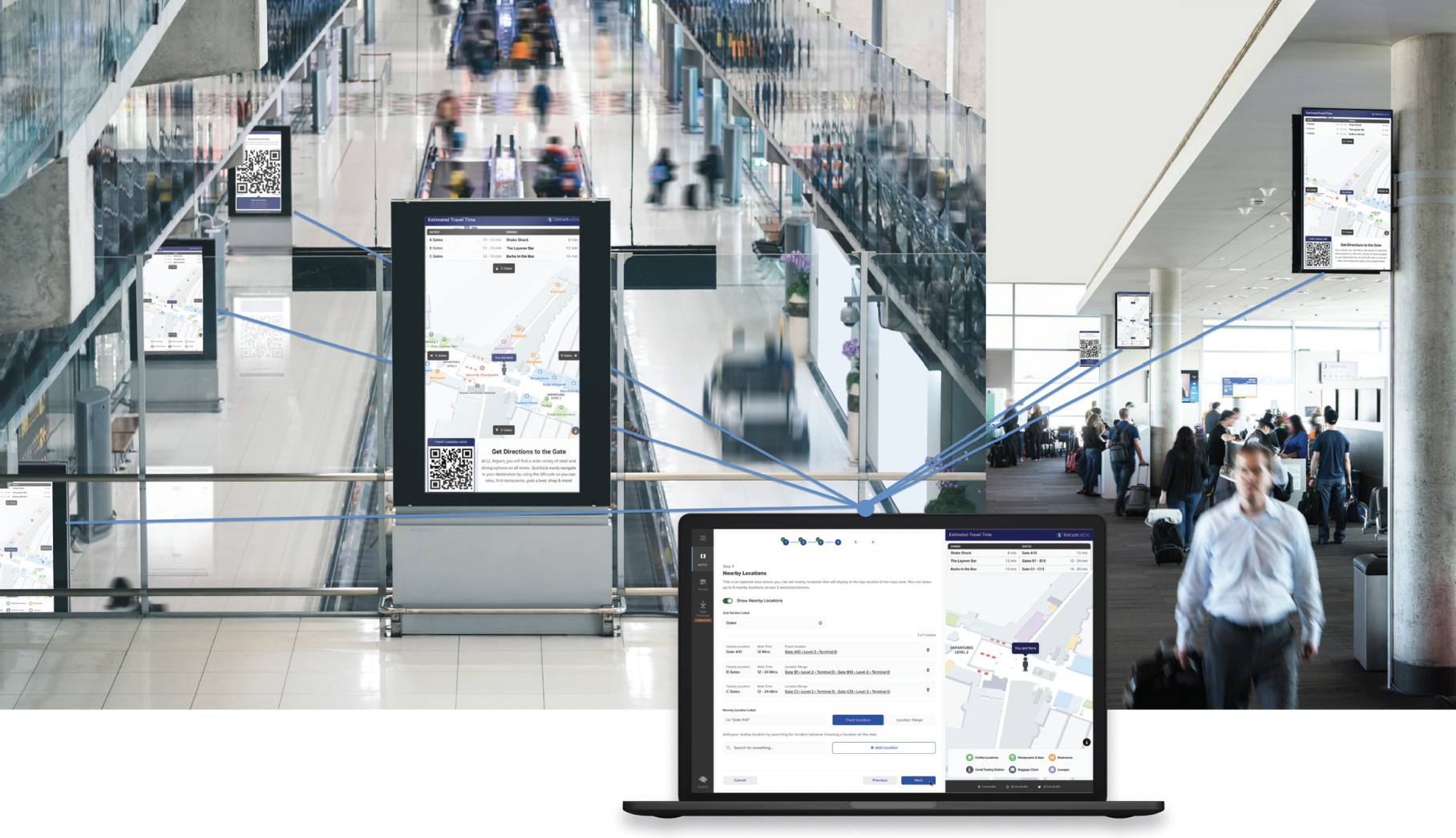
The scenario: Most passengers enter the airport through the doors closest to the rideshare drop-off, frequently stopping at the nearest digital directory.
Teams can create a unique QR Code for each digital display that initiates wayfinding experiences on passengers’ devices. The touchless handoff eliminates contact with public surfaces and reduces the need for people to congregate around the directory.
Passengers can access location-specific information, interact with it on their personal devices, and move throughout the airport guided by step-by-step navigation.
Seamless connections between existing digital signage and passenger devices reassure passengers the airport teams are working with them to meet their travel and information needs. Unique QR codes on screens invite passengers to access the interactive maps and wayfinding functions on their personal device in a completely contactless interaction.
Configure every detail on each display
The scenario: A new café opens in Terminal C, located just out of view from the most crowded gate areas.
Teams can strategically highlight the café on select screens making it easier to discover, create awareness, and drive foot traffic. The ability to display specific places of interest in the context of passenger location is also particularly beneficial for redirecting travelers from out-of-service bathrooms or concessions.
Passengers can “see” the alternative restrooms, concessions, and new café, even though these places are beyond their sightline. Our software’s contextual feature encourages passengers to visit the café by displaying a digital coupon for a free muffin with coffee on their phone screen as they’re scrolling through the café menu. On-screen walk times give them the confidence to find the café and explore beyond their gate, knowing they can make it back before boarding.
Maps on Digital Display allows communications staff to customize content for each display to maximize engagement and help customers maintain their orientation while enjoying different airport areas. Highlighting location-relevant points of interest shows passengers what’s available in the surrounding physical space.
Airport employees can even manipulate map orientation to match the passenger’s current point of view in the airport, ensuring intuitive viewing and navigating.

Create, publish, and manage content in a centralized map management tool*
The scenario: Passengers need to be informed about temporary renovations in Terminal A that impact available concessions and routes to and from the area.
Teams can make passengers aware of current updates by pushing gate closure notices and construction warnings to every digital display surrounding the affected area. They indicate blocked construction zones in wayfinding apps and showcase the restaurant closure.
Passengers see real-time updates about the construction, their new gate location, and amended step-by-step walking directions. Crucial information travelers need to adjust to the temporary changes is immediately visible from displays and their browser-enabled devices, without guessing or frustrating searches.
Managing spatial data within the Atrius® Venue Management System (VMS) enables airport teams to create, edit, and control content displayed across a vast network of screens and devices from a single, centralized platform without any dependencies. In this instance, construction or terminal updates are entered in the VMS and pushed instantly and simultaneously to all digital airport maps.
*Separate purchase of Atrius® Personal Wayfinder solution required.
Reshape how people operate, work in, and travel through your airport
Information changes quickly in complex, integrated systems like airports. Which means it must move quickly, too. We trust our airport customers understand their physical spaces best – they know precisely when and where to display certain content to achieve a specific goal.
Maps on Digital Display delivers an unprecedented level of precision and control over content distribution. Airport terminals are no longer passive. Activating the physical space with location-relevant information influences passengers to take specific actions and helps them explore confidently.