Indoor Mapping Software for Airports & Other Complex Spaces
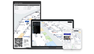
Navigating large, complex venues like airports requires more than just static maps, it demands an intelligent indoor mapping solution. Atrius® Wayfinder delivers dynamic, blue-dot-enabled navigation across web, mobile, and digital displays, helping visitors find their way with ease while improving operational efficiency. With centralized geospatial data management, intuitive route planning, and seamless integration across digital platforms, Atrius Wayfinder transforms indoor navigation into a streamlined, engaging experience for all users.

Trusted by


See how our customers have improved their indoor mapping experience

Improve the navigability of complex indoor venues

Centralized Venue Data
Gain greater spatial data control, accuracy, and sharing within a central venue management system that allows organizations to easily manage their spaces.

Intuitive Navigation for End-Users
Guide visitors through your complex spaces with blue-dot-enabled technology like GPS, BLE, or VLC, assisting them to find any location or service with ease.

Simple Map Setup
Deploy production-ready digital maps without developers and graphic designers, helping organizations to have a ready-to-use system as quickly as possible.

“With Blue Dot technology and experience catering to airports worldwide, Atrius is a trusted and valued partner in implementing airport wayfinding technology.”